Traveling with two young children, we are often looking for the most direct way to get from point A to point B. We still take time to explore but if we’d like to be through the Prado museum (Madrid) before lunch, for example, then we want to walk straight there, enjoy ourselves, learn a lot, and return home for meal and naps.
Therefore we do bring our cell phones, specifically for the GPS navigation. T-mobile and some other carriers will not charge for data and text (careful making actual phone calls!) so it’s worth it for us. It’s very helpful when landing in a new city and getting straight to your hotel or apartment and for searching for the nearest grocery store.
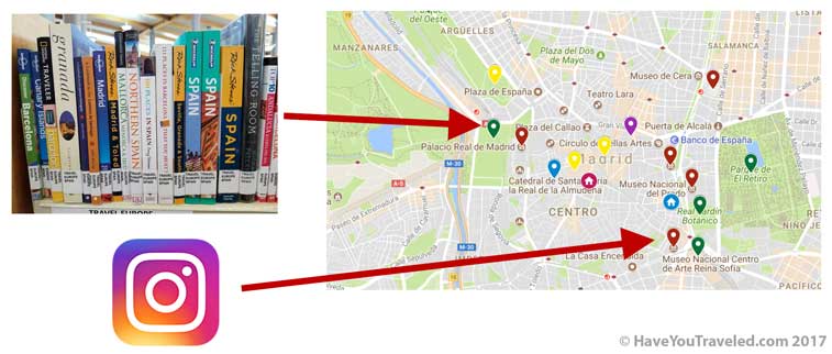
You may be familiar with Google maps but not everyone knows that you can actually create your own custom maps.
We don’t get too carried away here but we do add the sights we’d like to see as well as plenty of parks, restaurants (ice cream shops!), and other points of interest. That way we can enter an address straight from our phone and go straight there or we can see what is close by if we have some time on our hands.
Here is a 1min video explaining MyMaps.
We keep it simple.
First we start with the must-see and the must-do, like meeting places for tours we’ve already paid for, our home base, and other important places (parks). Then, as we get closer to our trip we’ll add things from our Instagram bookmarks or little fun things from the guidebooks we might see or do if in the neighborhood (nuns selling cookies through a secret door!?).
Maps in Spain
Below are our not-too-fancy-maps from our trip to Spain this spring. Notice the color-coding, the use of different icons for Home and Bus Station, etc. You can click on any of the pins and see website, address, and phone number. If we were more thorough we could’ve added any info we wanted to each. But for us we wanted location and a few categories if, for example, we needed to find a park for a picnic we were ready.
You can also tell from our maps we spent multiple days in Madrid and Sevilla but our day trips to Toledo and Granada we just wanted easy access to city center and back to train or bus station. In Córdoba, it’s bare minimum since we were only looking to drop luggage off in lockers and be back to train station 5 hours later.
MADRID
TOLEDO
SEVILLA
GRANADA
CORDOBA
Ideas for kids
- 4 and 2 – we showed them maps of Spain and the cities we would go to; this can be printed out, shown on atlas or globe, or, like we have enjoyed doing, on a Shutterfly custom placemat so they can look at the map(s) every night at dinner;
- the 4 year old can find his way around a map
- the 2 year old just memorizes via visual recall (for example, seeing the striped arches of the Mezquita results in “Coooooor-do-ba, dad!”
- 7+ – they can add pins or strips of post-it to a family map of your destination, specifically when they go through guidebooks and find something they are interested in (you may have to help them plot on map);
- also a great opportunity to discuss geography of the destination, climate, latitude, etc.
- 10+ – same as above; add access to digital maps;
- they may even be savvy enough to add visuals and/or short descriptions;
- note: MyMaps includes layering feature; perhaps they get their own layer to be strategically revisited during trip, “Ok, Noah’s turn to choose the next activity, let’s look at his map to see what’s close by.”
- 13+ – same as above; recruit them to figure out best routes to travel, perhaps even on foot, by bike, metro, or taxi. Or just to highlight neighborhoods worth exploring.
Family conversation topic: Who can help with the navigation duties each day? Do they need an assistant?
When is getting “lost” a good thing??